Overview
This topic describes the features, benefits, and use cases of HBase Ganos.
ApsaraDB for HBase Enhanced Edition has been upgraded to Lindorm. For new use cases, we recommend that you use the Lindorm Ganos service.
What is HBase Ganos?
HBase Ganos is an Alibaba Cloud spatio-temporal big data engine for managing spatial geometry data, spatio-temporal trajectory, thematic raster, and remote sensing image. It is compatible with open source ecosystems such as GeoMesa and GeoServer and includes built-in algorithms for efficient spatio-temporal indexing, spatial topology, and remote sensing image processing. Combined with the distributed storage of ApsaraDB for HBase and Spark's analytics capabilities, HBase Ganos is widely used to store, query, analyze, and mine spatial, spatio-temporal, and remote sensing big data.
Features
Version 2.0
Supports spatio-temporal geometry.
Supports data representation and modeling for spatial geometry and spatio-temporal trajectory.
Create, write, index, query, and delete spatio-temporal geometric objects.
Integrates with Spark for analytics and provides GeoSQL access compliant with Open Geospatial Consortium (OGC) standards.
Supports development using both SDKs and REST APIs.
Compatible with HBase 1.x.
Version 2.5
Includes all spatio-temporal geometry features of version 2.0 and adds spatio-temporal raster capabilities.
Provides fast Extract, Transform, Load (ETL) ingestion for raster data, including chunking, pyramid building, and time-dimensional indexing, and offers a native Spark processing library.
Offers a REST API for spatio-temporal queries on raster databases.
Supports services such as WMS/WMTS and provides a native GeoServer plug-in.
Compatible with HBase 2.x.
Use cases
Ride-sharing and mobility services
Handles high-concurrency trajectory writes, historical trajectory storage, order trajectory queries, and spatio-temporal range queries. This capability supports core business functions such as vehicle dispatching, ride-pooling, supply and demand forecasting, and heatmap analysis.
Sensor network and real-time GIS
In fields such as environmental protection, meteorology, water conservation, and maritime and aerospace monitoring, various sensors collect full-lifecycle, multi-scale monitoring metrics for geographic phenomena, events, and elements. Examples include pollution monitoring, water level monitoring, rainfall monitoring, and navigation aid monitoring.
Raster-based GIS and remote sensing applications
HBase Ganos provides a universal model for raster data management. It supports the storage, querying, and basic analysis of large-scale remote sensing image and GIS raster grid data. It includes ETL tools for reprojecting, mosaicking, tiling, and ingesting remote sensing images, supports OGC WMS/WMTS services, and integrates with a high-performance Spark engine for large-scale raster image analysis and processing.
IoT
Many IoT applications generate data with both time-series and spatial characteristics. In Internet of Vehicles (IoV) scenarios, for example, a massive number of vehicles continuously generate trajectory data that includes time and location. With HBase Ganos, you can monitor vehicle trajectories in real time, detect route deviations, and check whether a vehicle enters a restricted area. In addition to real-time monitoring, you can also perform real-time spatio-temporal queries, such as retrieving trajectories for a specific period or vehicles that entered an area during a specific time window. Combined with big data analytics frameworks such as Spark, you can also perform trip-line analysis and generate regional distribution heatmaps.
Intelligent logistics and food delivery
In logistics and food delivery, you need to monitor the real-time locations of vehicles and couriers to provide reliable services such as estimated time of arrival (ETA). The system must handle high-concurrency location updates from vehicles and couriers while performing real-time computations for route planning and deviation monitoring.
Benefits
Offers an out-of-the-box, cloud-native NoSQL big data engine for integrated spatial, spatio-temporal, and remote sensing data processing.
Supports petabyte-scale storage, high-concurrency writes, and returns results for spatio-temporal queries on tens of billions of data points in seconds.
Reduces storage costs for massive datasets with support for hot/cold data separation and efficient compression algorithms.
Offers seamless integration with Spark to quickly build a spatial data warehouse and analytics platform.
Facilitates system integration and interoperability through a design based on OGC standards.
Benefit from a reliable and stable fully-managed service operated by the professional ApsaraDB for HBase team.
Typical examples and architectures
Maritime vessel big data platform
Scenario: Ingests hundreds of millions of real-time Automatic Identification System (AIS) vessel location data points daily. The system requires responses within seconds for spatio-temporal and time-series trajectory queries, including:
Real-time geofencing checks for regulated areas.
Trajectory replay for a specific area and time range.
Trajectory replay for a specific time range.
Architecture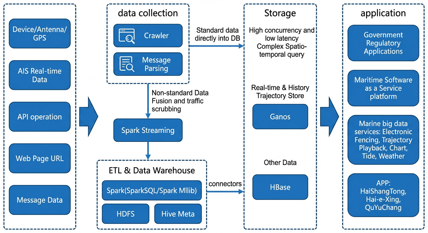
After cleansing and fusing AIS and other data on the Spark platform, you can build a data warehouse.
Store data for external queries in HBase Ganos, allowing front-end applications to perform spatio-temporal queries such as geofencing and trajectory replay.
The overall system achieves millisecond-level query latency, and data cleansing is performed in minutes.
A location-based service platform
Scenario: Collects real-time trajectory data from over 400,000 terminals with a peak throughput of over 30,000 trajectory points per second. The platform provides services such as real-time location queries, geofencing, and trajectory similarity analysis.
Architecture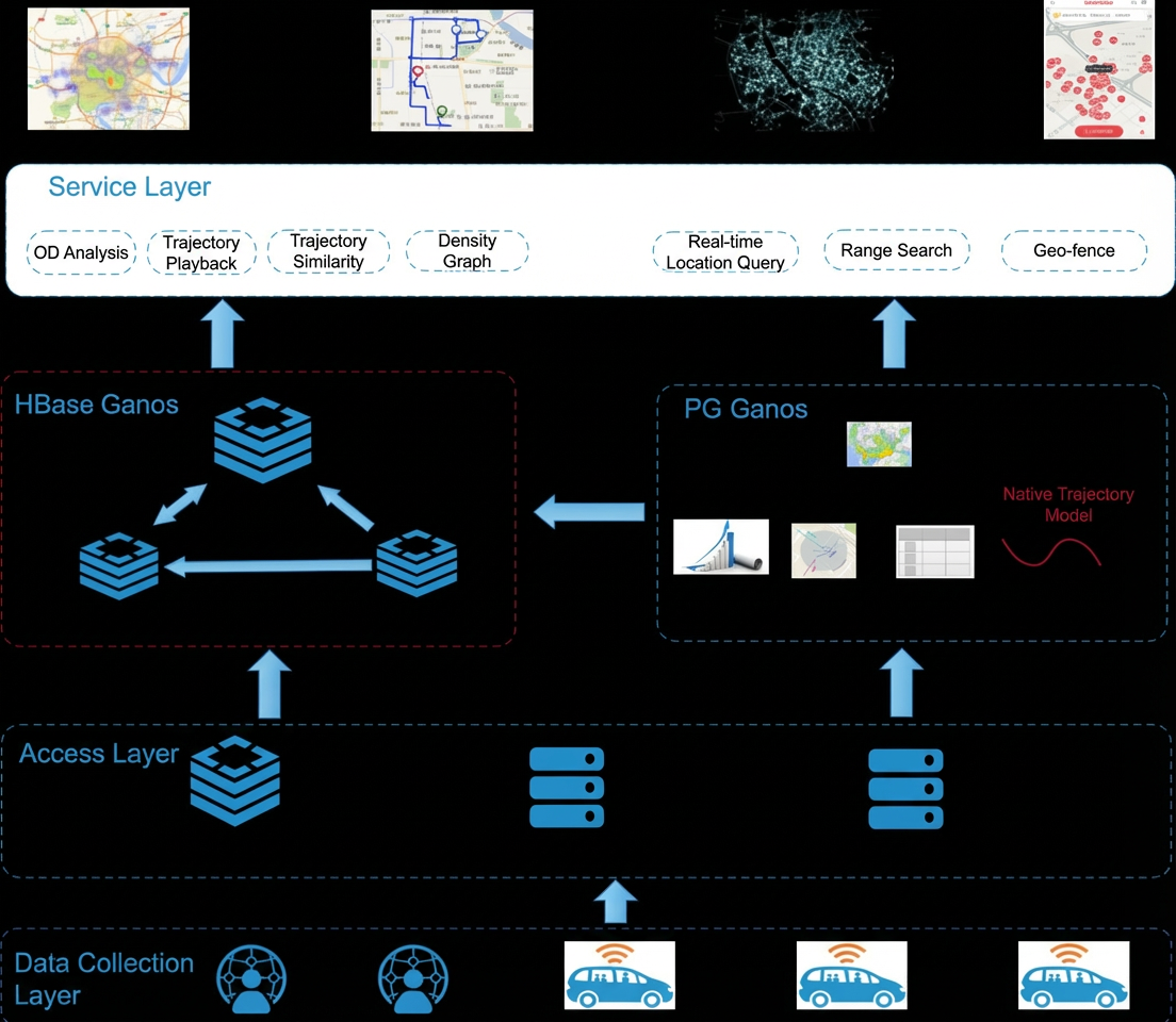
HBase Ganos stores all historical trajectory data.
When the historical data volume grows large, you can use the automatic cold data archival feature to move data to Object Storage Service (OSS), reducing costs by over 70%.
Queries over tens of billions of trajectory records, such as finding trajectories within a specific time and spatial range, return results in sub-seconds.
Seamless integration with Spark provides powerful features such as trajectory similarity and OD analysis.
Remote sensing big data management and intelligent service platform
Scenario: Ingest, query, and analyze remote sensing image data and provide AI-based remote sensing services.
Pain points:
Remote sensing image datasets are large and grow rapidly, making storage inflexible to scale, expensive, and complex to manage.
Traditional static tiling methods are fast for display but cannot support analytical or AI-driven scenarios.
Querying and analyzing fused data from multiple spatial sources is difficult.
Architecture: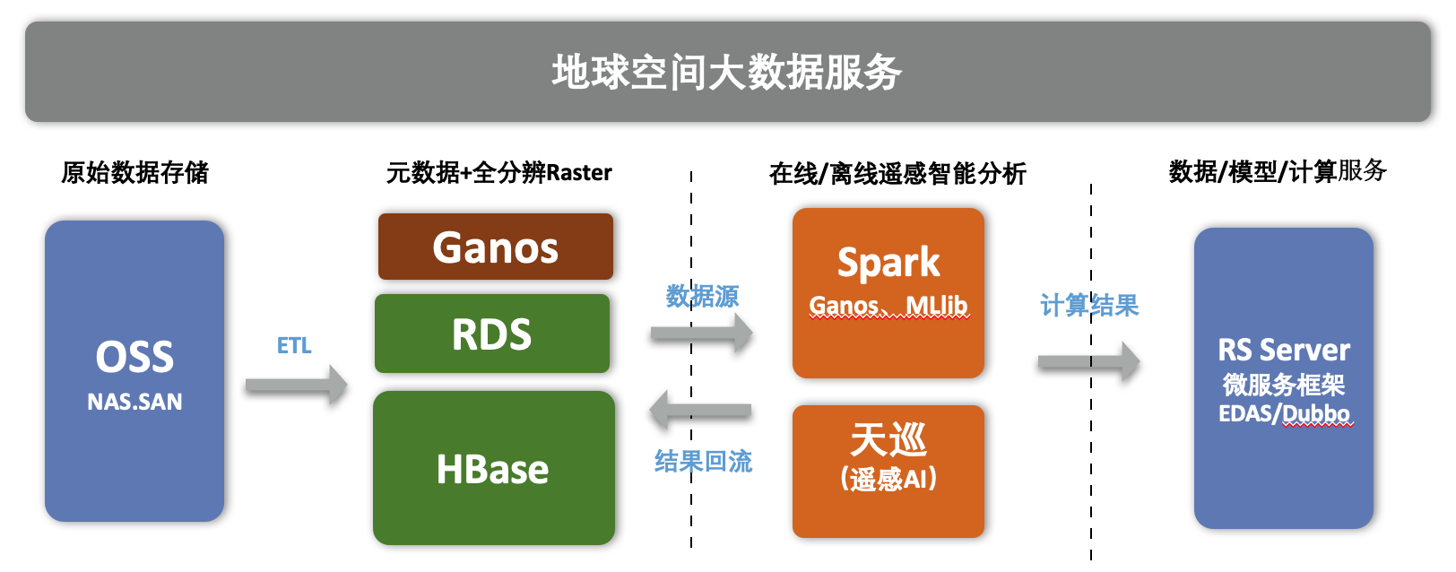
Raw data is stored in Object Storage Service (OSS) for cost-effective hot/cold data separation.
The image database uses a combination of SQL and NoSQL to build spatio-temporal image sequences with unlimited capacity, separating storage and compute for maximum elasticity.
Its native, chunk-based storage method preserves raw pixel information, effectively supporting various analytical and computational scenarios.
Integration with Spark simplifies ETL and multi-source spatial data analytics and processing.