This function computes the distance between a longest common sub-sequence (LCSS) sub-trajectory and a trajectory object.
Syntax
float8 ST_lcsSubDisatance(trajectory traj1, trajectory traj2, float8 dist, distanceUnit unit default 'M');
float8 ST_lcsSubDisatance(trajectory traj1, trajectory traj2, float8 dist, interval lag, distanceUnit unit default 'M');
Parameters
Parameter Name | Description |
traj1 | The first trajectory object. |
traj2 | The second trajectory object. |
dist | The distance tolerance between two points. The unit is meters (m). |
lag | The time tolerance between two points. |
unit | The unit of distance. Valid values:
|
Description
This function computes the sub-trajectory of trajectory object 1 in which trajectory points are consistent with those in the LCSS sub-trajectory, and then returns the ratio between the total number of trajectory points in the sub-trajectory of trajectory object 1 and the number of trajectory points in the LCSS sub-trajectory.
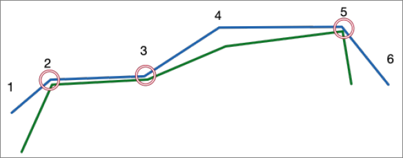
In the figure above, the points [2,3,5] form the LCSS trajectory segment. The corresponding segment in Trajectory 1 is [2,3,4,5], and the result is 1-3/4.
A smaller value indicates a higher similarity between the LCSS sub-trajectory and trajectory object 1.
Generally, a trajectory object has a valid SRID. If not specified, the SRID is 4326 by default.
Examples
With traj AS (
    Select ST_makeTrajectory('STPOINT', 'LINESTRINGZ(114.000528 33.588163 54.87 , 114.000535 33.588235 54.85 , 114.000447 33.588272 54.69 , 114.000348 33.588287 54.73 , 114.000245 33.588305 55.26 , 114.000153 33.588305 55.3)'::geometry,
                             ARRAY['2010-01-01 11:30'::timestamp, '2010-01-01 11:31', '2010-01-01 11:32', '2010-01-01 11:33','2010-01-01 11:34','2010-01-01 11:35'], NULL) a,
           ST_makeTrajectory('STPOINT', 'LINESTRINGZ(114.000529 33.588163 54.87 , 114.000535 33.578235 54.85 , 114.000447 33.578272 54.69 , 114.000348 33.578287 54.73 , 114.000245 33.578305 55.26 , 114.000163 33.588305 55.3)'::geometry,
                             ARRAY['2010-01-01 11:29:58'::timestamp, '2010-01-01 11:31:02', '2010-01-01 11:33', '2010-01-01 11:33:09','2010-01-01 11:34','2010-01-01 11:34:30'], NULL) b)
Select st_LCSSubDistance(a, b, 100) from traj;

st_lcssubdistance
------------------------
 0.66666666666666666667
 (1 row)

 With traj AS (
    Select ST_makeTrajectory('STPOINT', 'LINESTRINGZ(114.000528 33.588163 54.87 , 114.000535 33.588235 54.85 , 114.000447 33.588272 54.69 , 114.000348 33.588287 54.73 , 114.000245 33.588305 55.26 , 114.000153 33.588305 55.3)'::geometry,
                             ARRAY['2010-01-01 11:30'::timestamp, '2010-01-01 11:31', '2010-01-01 11:32', '2010-01-01 11:33','2010-01-01 11:34','2010-01-01 11:35'], NULL) a,
           ST_makeTrajectory('STPOINT', 'LINESTRINGZ(114.000529 33.588163 54.87 , 114.000535 33.578235 54.85 , 114.000447 33.578272 54.69 , 114.000348 33.578287 54.73 , 114.000245 33.578305 55.26 , 114.000163 33.588305 55.3)'::geometry,
                             ARRAY['2010-01-01 11:29:58'::timestamp, '2010-01-01 11:31:02', '2010-01-01 11:33', '2010-01-01 11:33:09','2010-01-01 11:34','2010-01-01 11:34:30'], NULL) b)
Select st_LCSSubDistance(a, b, 100, interval '30 seconds') from traj;
st_lcssubdistance
-------------------
0.666666666666667
(1 row)